From the 1899 Publication:
" During our circuit of the mountain, made near timberline the latter part of July, we saw what we took to be signs of conies among rocks east of Mud Creek Canyon, but finding no more believed we had been mistaken, until the evening of July 24, when we camped on some rivulets of snow water on the north side of Shastina. Here we found a small scattered colony reaching up in the slide rock from about 8,000 to nearly 10,000 feet, and a specimen was secured by Vernon Bailey. The next day we found signs in Cascade Gulch a mile or two northwest of Horse Camp. Later, when camped in the alpine hemlocks on the small west branches of Squaw Creek, we found a colony in the slide rock close by. Conies were afterwards found on both sides of Red Butte and on the east side of Gray Butte, and Osgood heard one near the head of Mud Creek Canyon."
Mud Creek Canyon is one of the major landmarks on Mount Shasta.
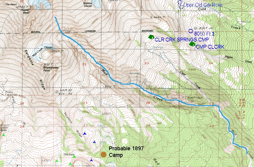
The Blue Triangles mark Ochotona locales near the 1897 Camp of C. Hart Merriam et al.
The reference "signs of conies among the rocks east of Mud Creek Canyon" has not been verified. I've searched and have found two or three "possible" talus slopes, but I have not found any pika (or sign).
The other reference: "Osgood heard one near the head of Mud Creek Canyon" leaves open the question of at what elevation Mr. Osgood heard the pika and how "near" he was to Mud Creek or the "head of Mud Creek." This is a very large area at any rate. I've searched throughout most, but certainly not all, terrain between the camp and Mud Creek between 8,000 to 9,000.' In this I've found two "possible" talus slopes, but I have not found any pika (or sign).
Back to results