Since the logging roads that once accessed this area are all closed to the public, the best access I found to Devil's Garden is by foot from behind Weed High School at 3,600'. There is a small parking area and trail leading off toward "Company Springs" -- the source of drinking water for much of the city of Weed. The roads to Devil's Garden bypass the springs by 100' or so. See route map for exact roads to take to get to the area at the top of the lava flow. The lava flow can be spotted on the walk up, but is not obvious from the roads.
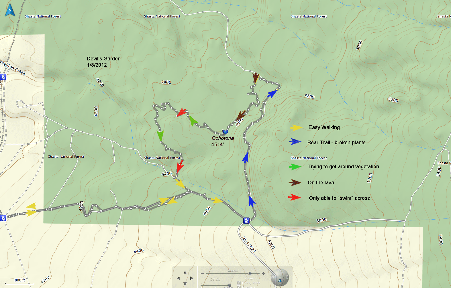
The yellow markers on the map above are all on logging roads and make for an easy walk. On the map above notice where the trail marker begins the portion of the route marked with blue arrows. This road leads north around the edge of a hill. As soon as I left the logging road I noticed lots of bear scat -- in the manzanita-- a common sight around here. As the "road" degraded rapidly into a trail I realized that the "trail" was nothing more than a game track. I am used to finding and following deer trails all over where I've been searching for pikas, but this was different -- this was a bear trail. Not only was the scat obvious, but the large broken Ceanothus velutinus and others were good evidence that a large-bodied, not-very-careful animal was muscling through the brush. After making it around the hill and after descending a little, the brush got even closer and the trail was lost. Now down from the hill and heading toward the lava through the brush I heard a loud crash of vegetation that I took to be a large animal exiting the area, out of my sight, but not far away. Although I never had carried pepper spray on Mount Shasta before, I did bring along my "Bear Assault" canister I had from my trips into the Eddies, just west of Weed and considerably more bear-infested. So, I sat down and read the instructions. Although it recommends trying the canister before needing it, it also made the point not to practice in bear areas. Pepper spray? Don't let the bears smell the pepper spray? Bears like Mexican food!!!?
Before long I was out on the lava at the far north and east part of the "garden." This is indicated with brown markers on the map.I was amazed at how the basalt lava blocks allowed for very deep crevices. It was certainly a different geology than what I am used to in the andesite talus slopes. Although I didn't see any evidence of lava tubes or the tendency for those formations, there was enough relief on the lava to have most slope aspects represented. The traverse across the lava was not as difficult as I had feared but was slow and tedious. After hearing the pika and waiting, I made the decision to stay on the rocks and go west, slightly downslope. The brush looked too thick to just proceed south on the contour and make a narrow loop. Even by going downslope and staying on the rocks I ended up with vegetation hemming me in. Several attempts to make it across a small, vegetated ravine resulted in getting completely thwarted each time. The green arrows show the route trying to find passage ways through the brush. The red markers show the worst spots. In these, especially the last one, I had to "swim" through masses of Arctostaphylos patula, Ceanothus velutinus, Quercus chrysolepis in such a fashion that I couldn't usually see the ground-- I was standing on branches and moving quadrupedal by grasping--and the shrubbery was 10' above my head. I had taken a careful look and it seemed I had to travel about 50' through the mess until I would reach a clearing and the logging roads.
I left the Ochotona site at 3:30 pm and it took me until 5:30 to reach the clearing and the logging road. It was just getting dark. I had made the choice to try to loop around-- to come back through the flow rather than to exit the flow the way I came. It was almost a bad choice because the vegetation was such a barrier. I was never ultimately too worried -- I knew that I could always work my way down the entire flow on the lava-- to the railroad tracks. That would take a long time, but there was a full moon and it was nice weather. As it was, I made it to the logging roads by dark and back to my car by 7:00 pm. It was a 10.4 mile round trip hike, starting at 3,600' climbing to 4,800. Devil's Garden might be 3.5 miles east of Weed, but to get to the pika locality, one needs to hike more than that.
My best thought for a return trip is to study Google Earth aerial photos to see if I can't find a "rock only" path into the site.